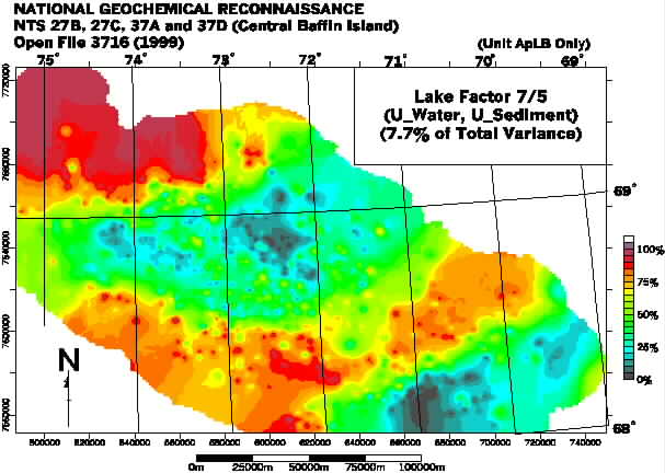
The principal agency represented by this factor is almost certainly uranium in Archean and Aphebian granites, which make a contribution to the composition of the lake sediments and waters even though the Longstaff Bluff Formation is the predominant catchment-basin lithology in all cases. The concentration of high scores in the southeast is possibly due to the dispersion of uranium by tidewater (see Factor 6); certainly, the concentration of uranium in water, considered individually (not shown here) is more anomalously high than that of uranium in sediment in this region.
Factor scores show a strong positive correlation with sample depth, at least up to depths of 40 metres. The trend seems to reverse at greater depths although only six samples were collected at depths greater than 40 metres so this may not be statistically significant. Scores for samples recorded as being black, or some combination of black with some other colour, seem to be higher than for other colours. This is probably related to uranium's well documented affinity for organic matter. The non-appearance of loss-on-ignition (L.O.I.) amongst the strongly-loaded variables in this factor (only 0.074) may be related to the relative paucity of organic matter in the lakes of the High Arctic, and the relatively greater contribution of other components (e.g. carbonate content) to what is measured as Loss on Ignition.